

 InfoSearched
A single dash-cam captured every mile from the Pacific to the Atlantic, compressed into one unbroken time-lapse.
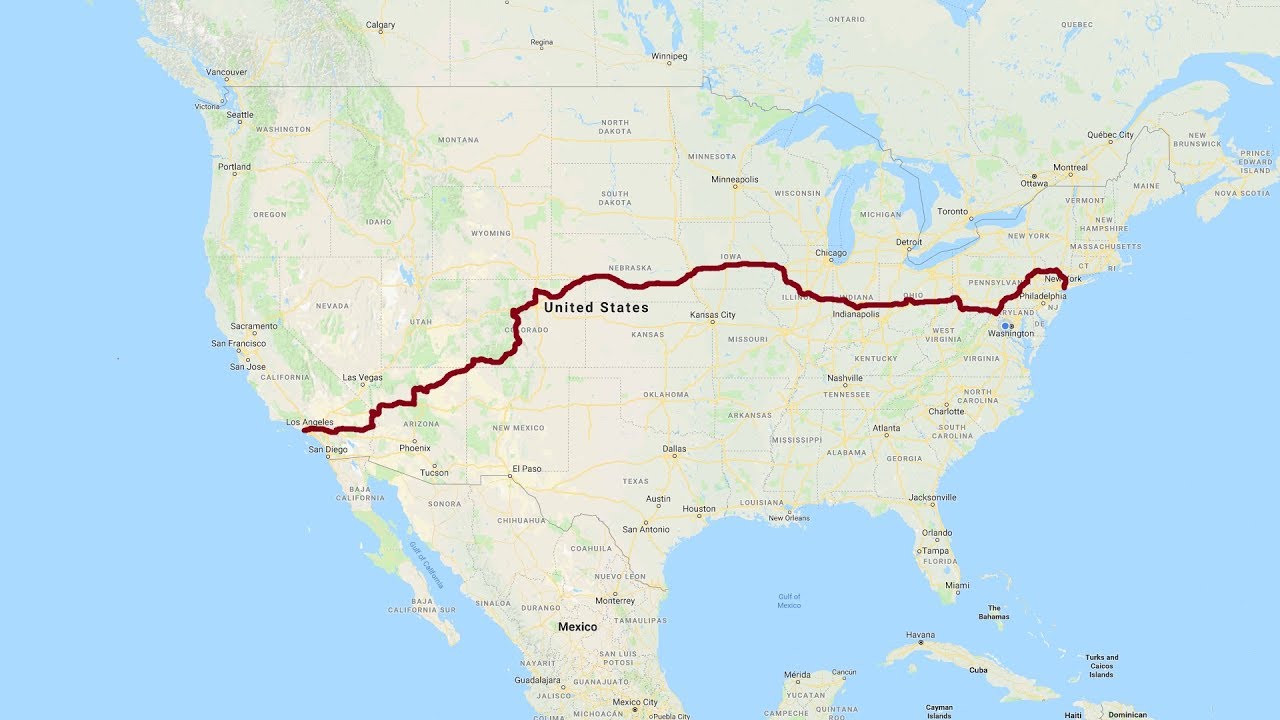
California to New York: A Complete Road Trip, produced by Unclecoolie Productions, stitches together eight separate days of driving into one continuous journey from Santa Monica to New York City. Filmed between June and September 2017, the footage covers 3,253 miles (5,235 kilometers) and was assembled at four frames per second from roughly 100,000 individual frames. It’s less a travel vlog than a document — a full coast-to-coast crossing rendered as one uninterrupted drive.
- The route crosses the Continental Divide three times, topping out at 11,539 feet (3,517 meters) — the drive’s highest point — and later hitting 11,158 feet (3,401 meters), the highest elevation on the entire U.S. Interstate Highway System.
- The recording rolls straight through the August 21, 2017, solar eclipse in Nebraska and crosses the original Tappan Zee Bridge roughly a month before its permanent closure, just ahead of the Gov. Mario M. Cuomo Bridge opening beside it.
- Nearly the entire trip was shot in daylight, with only about ten minutes of night driving through Arizona and roughly three miles left unrecorded, mostly near Poncha Springs, Colorado.
Eight Days, One Continuous Drive
Piecing together footage shot across four months and eight separate travel days into a single seamless time-lapse is its own kind of editing feat. The final cut plays like one long day behind the wheel, moving from the Santa Monica coastline eastward across deserts, mountain passes, and plains before dropping into Manhattan. It sits in the same lane as other long-haul driving documentaries that have found an audience online, including footage like WE DROVE OUR VAN 1,461 MILES ACROSS AMERICA, though this project covers more than double the distance and compresses it into a far tighter runtime.
The gaps are almost as telling as the footage itself. Of the 3,253 miles logged, only about three miles went unrecorded — mostly around Poncha Springs, Colorado — and just ten minutes of the entire compilation happen after dark, during a night stretch through Arizona. Everything else plays out in daylight, which is part of what makes the elevation and weather shifts so visible frame to frame.
Three Trips Across the Continental Divide
The Rocky Mountain stretch is the physical high point of the whole trip, literally. The route crosses the Continental Divide three separate times: first at 10,856 feet (3,309 meters), then at the drive’s overall peak of 11,539 feet (3,517 meters), and finally at 11,158 feet (3,401 meters) — a crossing notable for being the highest point anywhere on the U.S. Interstate Highway System. Anyone who’s chased that same Colorado high country on camera knows how quickly the terrain turns, a theme covered in a different context in EXPLORING THE MOUNTAINS OF COLORADO! Summer Travel Vlog 2020.
Three Continental Divide crossings, one topping out at 11,539 feet — and the third marks the highest elevation on the entire U.S. Interstate System.
An Eclipse in Nebraska, a Bridge on Borrowed Time
Two moments in the footage double as historical markers rather than just scenery. The drive passes directly through the path of the August 21, 2017, solar eclipse while crossing Nebraska, putting a rare astronomical event on camera almost by accident of timing. Further east, the route crosses the original Tappan Zee Bridge in New York roughly a month before it was permanently closed, just before traffic shifted onto the newly opened Gov. Mario M. Cuomo Bridge running alongside it — meaning the footage preserves a structure that no longer carries traffic.
Weather stayed largely clear for most of the crossing, but conditions turned overcast and rainy from Pennsylvania through the Bronx, before the skies cleared again right as the drive reached Manhattan — a fitting final stretch for a trip that started under the California sun.
Extreme Swings in a Single Afternoon
The desert leg produced the sharpest temperature swing of the whole trip. The hottest reading came in at 110°F (43°C) in Needles, California, while the coldest, 53°F (11°C), hit in Tusayan, Arizona — a 57-degree swing across just 230 miles (370 kilometers) of driving. It’s the kind of contrast that only shows up when you’re logging every mile back to back rather than breaking a cross-country drive into separate legs over separate trips.
That’s the appeal of the whole project: it’s not a highlight reel of postcard stops, it’s the connective tissue between them — the actual 3,253 miles most road-trip footage skips past on the way to the next attraction.







INDIA’S HIPPIE VILLAGE: HAMPI
North Korea / The Lies and Truth of Kim Jong Un / How People Live
Is Star Wars Land Still Crowded? | New Stores, Single Rider On Smuggler’s Run & Friday The 13th Fun!
Inside Bali’s Bamboo TREEHOUSE Paradise
City of the Future: Singapore – Full Episode | National Geographic